Pillar 1 · proven
Functional baseline platform
Autonomous GPS waypoint missions flown in field tests. NVIDIA Jetson Orin Nano for onboard AI, linked into our edge-to-cloud stack.
Built for high-risk terrain such as border zones, where GPS is jammed or absent and crashes are likely. Three development pillars converge into one virtually indestructible platform, running on our 4-tier edge-to-cloud stack.
Autonomous GPS waypoint missions flown in field tests. NVIDIA Jetson Orin Nano for onboard AI, linked into our edge-to-cloud stack.
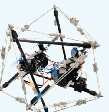
An icosahedron of rods and cables spreads impact loads. Drop-tested: it absorbs crash energy and rebounds. Targets: under 1.2 kg, 5–10 m/s impacts, self-righting in under 10 s.
Pipeline designed: sensors fused on Jetson, with the SLAM pose replacing GPS in the flight controller. Next: bench-test SLAM, then contained indoor flights.
Surveillance and reconnaissance, border and perimeter patrol, and target identification and tracking — for Army, Air Force and Navy.
Inspection of plants, tunnels and pipelines, indoor mapping and site surveys — wherever GPS is weak and crashes are costly.
We are looking for design partners to trial the tactical UAV in GPS-denied conditions. Tell us about your mission.